Greg James

Far West Coast


Greg James' Fishing Pathfinder - GPS Marks for Far West Coast
Tyre Modules Peabees The Bank Chan's Goalen Rocks Marj's Knuckles Jonesies Thev Changa GeeGee Trax Dunka TeaBee Alarm

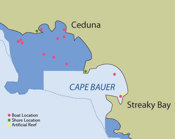
Boat Fishing Locations

Name:
GPS:
Fish:

Thev
32°08'20"S, 133°39'06"E
blue crabs, razorfish

Name:
GPS:
Fish:

Jonesies
32°12' 58"S, 133°38'56"E
whiting, blue crabs

Name:
GPS:
Fish:

Knuckles
32°16'58"S, 133°15'31"E
whiting, snook, tommies

Name:
GPS:
Fish:

Marj's
32°21'54"S, 133°33'52"E
red mullet, whiting, snapper, squid

Name:
GPS:
Fish:

Goalen Rocks
32°24'56"S, 133°40'58"E
red mullet, whiting, mackerel

Name:
GPS:
Fish:

Chan's
32°46'04"S, 134°13'42"E
snapper, nannygai, trevalley

Name:
GPS:
Fish:

The Bank
32°33'03"S, 134°08'58"E
red mullet, salmon trout, tommies, whiting

Name:
GPS:
Fish:

GeeGee
32°15'43"S, 133°14'31"E
red mullet, whiting, snapper, trevalley

Name:
GPS:
Fish:

Trax
32°15'56"S, 133°13'52"E
whiting, snapper, red mullet, trevalley

Name:
GPS:
Fish:

Dunka
32°09'55"S, 133°28'06"E
yellowfin whiting, bream, mullet, salmon trout, tommies

Name:
GPS:
Fish:

TeaBee
32°13'42"S, 133°37'46"E
red mullet, whiting, snook, garfish

Name:
GPS:
Fish:

Alarm
32°19'01"S, 133°29'52"E
red mullet, whiting, snook, garfish


Shore Fishing Locations

Name:
GPS:
Fish:

Peabees
32°31'58"S, 133°51'34"E
salmon, mulloway, tommies, shark, sweep

Name:
GPS:
Fish:

Changa
32°10'54"S, 133°25'52"E
yellowfin whiting, bream, mullet, salmon trout, tommies

Name:

GPS:
Fish:

Stubby
(not on map, near Chadinga Conservation Reserve)
31°57'40"S, 132°46'57"E
salmon, mullet, snook, snapper

Name:

GPS:
Fish:

Sinkaz
(not on map, near Lake Macdonnell)
32°04'58"S, 133°00'09"E
salmon, mullet

Name:

GPS:
Fish:

Choox
(not on map, east of Fowlers Bay)
31°56'33"S, 132°29'37"E
salmon, mullet, snook

Name:

GPS:
Fish:

Allies
(not on map, south of Elliston)
33°52'25"S, 135°10'33"E
salmon, mullet, salmon trout

Name:

GPS:
Fish:

Fossils
(not on map, south of Elliston)
33°53'19"S, 135°11'14"E
salmon, mullet, salmon trout

Name:

GPS:
Fish:

Camels
(not on map, south of Elliston)
33°51'28"S, 135°09'02"E
salmon, mullet, salmon trout

Name:

GPS:
Fish:

Frenchmans
(not on map, south of Elliston)
33°44'31"S, 135°01'25"E
mullet, salmon, mulloway

Name:

GPS:
Fish:

Microz
(not on map, south of Elliston)
33°44'14"S, 135°01'02"E
mullet, salmon


Artificial Reefs

Type:
GPS:
Fish:

Tyre Modules
32°43'55.47"S, 134°14'48.77"E
whiting, snapper, morwong, grouper, snook